Trail Horseback riding La Tour-d'Auvergne - 2024-05-28_22h18m30_chastreix-baffaud-27km - Photo

2024-05-28_22h18m30_chastreix-baffaud-27km

© OpenStreetMap contributors
Length
Length
27 km
Max alt
Max alt
1486 m
Uphill gradient
Uphill gradient
738 m
Km-Effort
Km-Effort  
37 km
Min alt
Min alt
1060 m
Downhill gradient
Downhill gradient
739 m
Boucle
Boucle
Yes
Creation date :
2024-05-28 20:18:30.394
Updated on :
2024-06-15 07:04:16.633

(0 Reviews)

Horseback riding
Horseback riding
4h51
Difficulty : Difficult

Scan this QR Code to open this trail in the SityTrail application

FREE GPS app for hiking

Logo SityTrail SityTrail

IGN / Geographical institutes

Download SityTrail from the App Store Download SityTrail from Google Play

Logo SityTrail SityTrail World

The world is yours!

Download SityTrail from the App Store Download SityTrail from Google Play Download SityTrail on Huawei AppGallery

About

Trail Horseback riding of 27 km to be discovered at Auvergne-Rhône-Alpes, Puy-de-Dôme, La Tour-d'Auvergne. This trail is proposed by jacky jouve.

Description

Baffaud - Chambourget - Les Plaines Brulees - les Moulins - Le Capucin

Elevation profile

Positioning

Country:
France
Region :
Auvergne-Rhône-Alpes
Department/Province :
Puy-de-Dôme
Municipality :
La Tour-d'Auvergne
Location:
Unknown
Start:(UTM)
483168 ; 5044165 (31T) N.

Trails nearby

Trail Walking La Tour-d'Auvergne - Tour_Auvergne_Chambourguet - Photo
Walking
GUIDE
jagarnier

Walking

Difficult
(1)
La Tour-d'Auvergne, Auvergne-Rhône-Alpes, Puy-de-Dôme, France
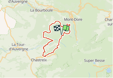
17.7 km | 24 km-effort
5h 0min
Yes
Trail Walking Mont-Dore - Montée au sommet du Puy de Sancy - Photo
Walking
GUIDE
pscheven

Walking

Easy
(1)
Mont-Dore, Auvergne-Rhône-Alpes, Puy-de-Dôme, France
1.4 km | 2.7 km-effort
40min
Yes
Trail Walking Mont-Dore - Mont_Dore_Puy_Sancy - Photo
Walking
GUIDE
jagarnier

Walking

Difficult
(1)
Mont-Dore, Auvergne-Rhône-Alpes, Puy-de-Dôme, France
6.8 km | 13.9 km-effort
2h 0min
Yes
Trail Walking La Bourboule - Bourboule_Vendeix_Charlannes - Photo
Walking
GUIDE
jagarnier

Walking

Difficult
(1)
La Bourboule, Auvergne-Rhône-Alpes, Puy-de-Dôme, France
15.4 km | 25 km-effort
4h 30min
Yes
Trail Walking Chastreix - Chastreix. cascades et tourbières  - Photo
Walking
olivier78000

Walking

Easy
(1)
Chastreix, Auvergne-Rhône-Alpes, Puy-de-Dôme, France
13.8 km | 18.3 km-effort
4h 5min
Yes
Trail Walking Mont-Dore - Le puy de la tache, le lacs servières et guèry par la cascade du Queureuilh depuis l'Escalidou.  - Photo
Walking
loloetienne

Walking

Difficult
(3)
Mont-Dore, Auvergne-Rhône-Alpes, Puy-de-Dôme, France
34 km | 50 km-effort
10h 16min
Yes
Trail Walking Mont-Dore - le sancy du mont dore par le côté ouest puis revenir par le côté est.  - Photo
Walking
loloetienne

Walking

Difficult
(2)
Mont-Dore, Auvergne-Rhône-Alpes, Puy-de-Dôme, France
8.2 km | 15.4 km-effort
3h 5min
Yes
Trail Walking Mont-Dore - Sentier des crêtes Puy de Sancy - Photo
Walking
tracegps

Walking

Difficult
(2)
Mont-Dore, Auvergne-Rhône-Alpes, Puy-de-Dôme, France
26 km | 46 km-effort
9h 0min
Yes
Trail On foot Mont-Dore - Le Mont-Dore / Lac Chambon - Photo
On foot
PRO

On foot

Difficult
Mont-Dore, Auvergne-Rhône-Alpes, Puy-de-Dôme, France
19.4 km | 31 km-effort
7h 6min
No


Close
My subscriptions